Charting a Course: Bayou Teche Flows through Time

Map showing the path of the Bayou Teche, which begins in Port Barre and flows southward to Berwick.
Shrouded in the mist of an early morning, the Bayou Teche looks timeless, almost as it must have to the first European settlers who traveled here. However, the Teche has changed with geological meandering of the Mississippi River, agricultural settlement, and industrial growth of the cities along its banks. Despite these changes, Bayou Teche remains a constant geographic link providing continuity from the past to the present.
Today, the bayou still holds fascination for visitors to The Shadows and is often the subject of many questions. Most seek an explanation of the differences between a bayou and other terms for waterways, including river, stream, and creek.
The definitions for bayou abound; however, most sources indicate that “bayou” developed from the Native American word “bayuk,” which means creek. The word for bayou is widely attributed to the Choctaws, although one source cited the Louisiana tribe of Muskhogeans as the group responsible for creating the term. The Muskhogean language was much like that of the Choctaw of Mississippi. A bayou is defined as a stream, creek, secondary watercourse, or minor river. According to Peter Feibleman in his book The Bayous, “geographers refer to a bayou to describe a watercourse that serves as a distributary, or natural outlet, of a river.” He indicates that Louisianans follow the Native American example and utilize the word “bayou” for almost every kind of watercourse. Whether it is a distributary or tributary, and whether it begins or ends in a river, lake, swamp or marsh, it’s still called a bayou.
Every 1000 to 1500 years, the Mississippi River changed its course. From 1900 B.C. to 700 B.C., the Mississippi flowed through the Teche to eventually empty through a deltaic plain into the Gulf of Mexico. While the Mississippi drains about 41 percent of the continental United States, the Teche today flows through five parishes and joins the Atchafalaya River near Morgan City. At one time, water from both the Red and Mississippi Rivers flowed through the Teche, but geological changes have caused these rivers to both change courses.
The word “Teche” came from the Native American word for snake or “tenche.” One Native American legend tells of an enormous silver snake who terrorized the region. Warriors used all their arrows on the snake and resorted to clubs to kill it. The dying snake cut grooves into the soil, which later filled with water, forming the Bayou Teche. Another Native American legend states that the snake was actually a protector of their early ancestors, and their people were invited to live alongside their protector.
Regardless of which tradition any one group may ascribe, Native Americans settled along the Teche’s banks to hunt, gather, fish, and grow crops. They were also attracted to the region because the Teche provided a major travel route. This function did not change as Europeans moved into the Attakapas region. “When pioneers moved into the region, the Bayou Teche was regarded as the only route of public transportation and communication,” wrote Glenn Conrad in an article for the Attakapas Gazette discussing the development of roads in the Attakapas region.
Descriptions of New Iberia and the Teche have been recorded by various visitors. The first official reports were from James Cathart acting as a government agent to locate live oak and red cedar for U.S. Navy shipbuilding after the War of 1812. From “A Pocket Gazetteer” published in 1834 by Plaskett & Co., Baltimore, “New Iberia, v.[village] Louisiana parish of St. Martin’s on the right bank of Teche 48 miles above its mouth, consisting of one street along the river containing 40 houses and 200 inhabitants. The bank is something higher than it is either above or below; schooners drawing four or five feet of water come up to New Iberia at all seasons. 30 degrees North.” The Teche is also described. “Teche, r.[river] Louisiana, flows S.E. and joins the Atchafalaya about fifteen miles above its entrance into the Gulf of Mexico. It is navigable to New Iberia, about forty-five miles.”
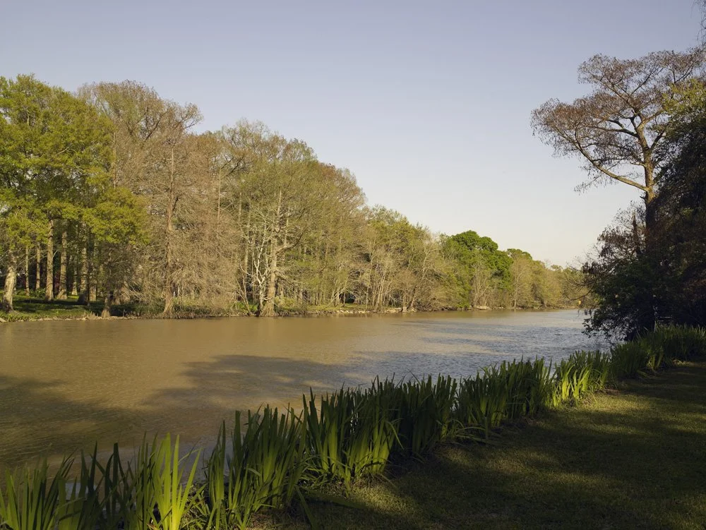
View of the Bayou Teche from the back yard of The Shadows. Photo courtesy of Carol Highsmith.
Others have also recorded their trips of Bayou Teche’s 125 miles beginning from Port Barre, where it leaves Bayou Courtableau, to Morgan City, where it joins the Atchafalaya. Daniel Dennett, publisher and editor of the Franklin Planters’ Banner, recorded his “Trip Up the Teche” in 1869 columns. He described settlements as well as soil and crops. “The poor old town of St. Martinville looks melancholy.” Dennett reflected that its buildings without tenants reminded him of bones without marrow. In a book published by Dennett in 1876, he incorporated information from Colonel Samuel Lockett, professor of engineering who had traveled along the Teche when he prepared a report of topological information for the state government.
These official reports of the Teche provide insight into the way the Teche looked in the nineteenth century, but surveys must continue periodically to record change. Harnett T. Kane wrote in The Bayous of Louisiana referring to bayous, “It is a place that seems often unable to make up its mind whether it will be earth or water, and so it compromises.”
Originally published in The Shadows Service League Newsletter (Vol. 18, No. 7), June 1996.
Edited by Adam Foreman, EdD, May 2026.